
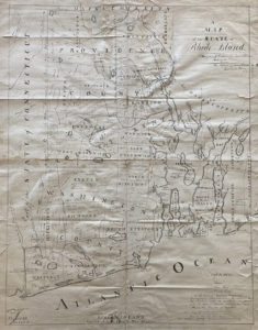
A map of Rhode Island detailing timber across the state [species and abundance]. FIC.2022.112, Collection of the Newport Historical Society.
In aid of ship-building efforts during the War of 1812 (a three-year conflict fought between the United States and Great Britain), Commodore Oliver Hazard Perry commissioned a timber map of Rhode Island. It identified most of the usable timber throughout the state’s cities and towns, by numbers and species.
Aquidneck Island and adjacent towns are clearly marked as having “no timber”, a result of the British Army having deforested the area for firewood during their occupation of Newport from 1776-1779. The map, signed by Perry, was drafted by James Stevens, civil engineer, and member of the Stevens stone carving family.